Metro News Release
For immediate release: September 20, 2012
Metro seeks input on newly redesigned Metrobus Maps
New design aimed at making network of bus service easier to understand and use
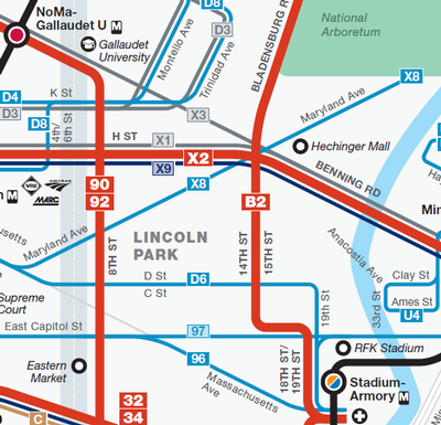
Metro has unveiled drafts of redesigned Metrobus Maps that more clearly depict bus routes and frequency of service, as part of ongoing efforts to provide clearer travel information for bus customers.
“While the current bus maps have served their purpose over the years, there is room for improvement to make the system easier to navigate for the more than 400,000 customers who take Metrobus each weekday,” said Lynn Bowersox, Metro Assistant General Manager for Customer Service, Communications and Marketing.
Among the improvements on the new maps:
- Major routes pop: Thicker lines indicate bus routes that operate more frequent service
- Simplicity is key: The map design provides an overview without attempting to depict every intricacy of every route.
- Clarity and readability are improved: Like the iconic Metrorail system map, geographic scale takes a back seat to clarity. As a result, customers will be able to more easily trace a bus’ route
- Reduced clutter: Minor landmarks have been removed to make the map easier to read and use
Metro operates more than 300 routes serving more than 11,000 bus stops in the District, Maryland and Virginia, making it one of the most extensive – and complex – bus networks in the country.
Metro hopes to gather additional feedback on the draft maps from bus customers over the next few weeks. Customer feedback and suggestions will be incorporated into the final map design. Customers can get more information, view the draft maps and provide feedback by visiting planitmetro.com.
The maps are expected to be finalized later this year.
To view the new maps and provide feedback, please visit PlanItMetro.com.
News release issued at 11:54 am, September 20, 2012.