Wayfinding and Service Updates - December 12

New Rail Line Order: A Step Toward Consistent Wayfinding
Metro is formalizing a uniform way to present Metrorail service lines throughout the system.
The new order is: Red • Yellow • Green • Orange • Silver • Blue
This new sequence shows how the lines lay out in the "built Metrorail environment" and on our systemwide map. Simply put, the Red Line is always on "top" (or upper level), and the Yellow and Green lines or Orange, Silver, and Blue lines are always on the "bottom" (or lower level).
Why We Made This Change
We're setting this new standard to create consistency across maps, signage, and digital tools, so you can navigate with confidence.
- Surveys and presentations to our Accessibility Advisory Committee (AAC) and Riders’ Advisory Council (RAC) showed strong support for this order.
- Aligning service information with our brand standards reduces confusion, builds trust, and strengthens the Metro identity.
- A clear, logical order helps eliminate errors and creates an intuitive, predictable navigation experience. This minimizes the mental effort required to move through a space.
This update is another piece of Metro's effort to rethink wayfinding, which now includes new station identifier signs (on the track side), new exit level signs, and exit letter identifiers both in static form and digital form.
Our work continues to make Metro easier to use and more welcoming for all customers.
Wayfinding and Service Updates - September 29
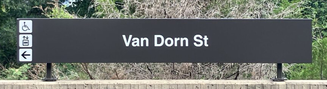
New Signs Now Arriving at Stations
We're updating station signage across the Metrorail system to make wayfinding easier and more resilient to change.

Track-Side Signs: Simpler, Smarter, and Consistent
Our new track-side signs focus on what matters most: station name and accessible travel path information (with a nod to the past, and present in some stations). By removing terminal destinations, we've reduced the need for frequent updates when service changes occur - saving time and labor (which means being more fiscally responsible) while keeping information clear and consistent.
Exit Signs: Introducing Lettered Exits and Points of Interest
We piloted a lettered exit system across a handful of stations and are now beginning to implement this across all stations. These new signs help you navigate to points of interest, local intersections, and transit connections more easily. Whether you're heading to a museum, a bus stop, or a neighborhood landmark, the new signs will guide your way.
Installation in Progress
As we install these signs, you may notice temporary gaps in signage at some stations. Our maintenance crews are working hard to swap out old signs for new ones - thank you for your patience during this transition.
More updates are arriving soon, including improvements to station maps and directional signage. Stay tuned and explore the new wayfinding experience as it rolls out systemwide.
Wayfinding and Service Updates - June 22

Silver Line Service Changes
A new service pattern began on the Silver Line, effective June 22, 2025, as trains now alternate between Downtown Largo and New Carrollton. This change improves frequency, and all system maps (digital and print) will soon be replaced to reflect this information. A hashed silver line now appears toward New Carrollton and Downtown Largo.
To help Metro more efficiently use its resources, the new paper maps will also show the extended Yellow Line scheduled for December 2025. A small decal will be on each printed map to serve as a reminder.
Weekend Hours
The rail system will open one hour earlier on Saturdays and Sundays, at 6 a.m. The system will close an hour later on Fridays and Saturdays, at 2 a.m.
First and last trains vary per station. Please use our Trip Planner and view station specific information.
Red Line Service Changes
Effective Monday, June 23, Red Line trains will run at least every four minutes (instead of every five minutes) during the busiest portions of weekday rush hours.
New Signage, Coming Soon, in Phases
Currently, customers may not see every sign, map, or navigation element updated to reflect the new service. This is because of the phased approach of service additions between now and December, along with the effort required in updating and replacing physical signs and maps throughout our system.
Metro encourages customers to use our digital navigation tools, which will be more accurate and reliable during this transition time.
Digital Navigation Tools
- Customer Information Screens on platforms
- Overhead "next train" arrival times
- MetroPulse, our new official app available on iOS and Android
- Onboard train destination signs
Metro is also replacing all bus stop signs and maps as part of the new bus network launching Sunday June 29. Metro thanks our customers for their patience as our crews prepare the region.
As this work continues, our Design Teams continue toward our goal of simplifying physical signage and other navigation elements over time - creating and installing improvements to our wayfinding, reflecting modern brand elements.
Wayfinding That Works for Everyone
Updates to signs across the system make it easier to get where you're going:
- New icons for exits, elevators, and escalators
- Simplified station wall signage with clearer directional info
- Updated platform and braille signage
- Shortened and consistent abbreviations including "Av" instead of "Ave." This change helps standardize our station names, which simplify and create more accessible designs (i.e., less characters = improved font size)
- System map enhancements with a new decal highlighting the future Yellow line change

Why It Matters
These updates are designed to improve your experience. Whether you're a visitor or a regular commuter, we're building a wayfinding system to help you navigate with more confidence. It's part of our larger Customer Experience strategy to modernize Metro and put our customers at the center of everything we do.
1. A Refined Logo
![]()
A modernized Metro logo now appears on our updated Metrorail system map. It's designed to work across digital and physical platforms, including employee uniforms.
2. Single-Letter Service Discs
Simpler, more accessible navigation debuts. Our new single-letter service discs (like "B" for Blue Line) are easier to read and understand for everyone, reducing clutter and unnecessary characters. These discs will appear on maps, signage, and digital displays to help you find your way more easily.
Where You'll See It First
As we build our capacity to produce and install these new signs, the first updates will appear at key Silver Line stations such as Dulles Airport and Stadium-Armory, with more rolling out in phases. We are prioritizing high-use and transfer stations to maximize impact and minimize disruption.
What's Next?
We'll continue to refine and expand these improvements - and we want your feedback!
Be sure to also keep an eye out for onsite and online surveys.
If you're approached by a Metro employee asking for feedback, please take a moment to share your thoughts. It helps everyone to have a better customer experience.
Also, check out our new native iPhone and Android app - MetroPulse - share immediate feedback by chatting with our Customer Service agents. You can connect with us in many other ways too.
Customer Service | Social Media | Alerts
- Customers can call 202-GO-METRO (TTY 202-962-2033), M - F, 7 am - 8 pm. Automated information is available 24/7.
- Follow @wmata, @metrorailinfo, and @metrobusinfo on X or @wmata.com, @metrorailinfo.bsky.social, and @metrobusinfo on Bluesky.
- For free service alerts via text and/or email, sign up for MetroAlerts.
Wayfinding and Service Updates - 2024
Our goal was to make it as easy as possible for you to orient yourself within our Metro system.
Accordingly, we developed signage showing an updated set of directional characteristics along with easy-to-understand icons.
Metro debuted the 1st wayfinding enhancements pilot program at L'Enfant Plaza (Fall 2023).
Since then, we have completed the 2nd round of wayfinding improvements at Gallery Place-Chinatown.

How It Started
We began by listening to you, the customer.
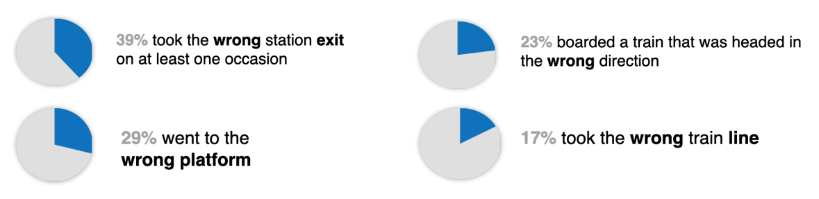
We conducted thousands of in-person and online customer surveys to better understand the problems encountered during your trips.
Creating An Easier Path
Once we learned that 39% of customers had taken the wrong entrance/exit on at least one occasion, we knew it was time to think of new ways to help our riders orient themselves to make better directional decisions.
Lettered Pathways
We took our survey results and incorporated global best practices seen in systems such as Tokyo, Seoul, and Paris that had introduced lettered pathways at key decision points outside and inside stations.

Now you will be able to find these letters on overhead signs, wall signs, the Station Manager kiosk/fare line, outside pylons, and on popular transit map mobile apps (e.g., Google Maps and Transit.)
 |

Entrance/exit lettering outside at Gallery Pl-Chinatown
|
Insights into Action
Over several months, we conducted online and in-person surveys to compare different pylons.
Accordingly, we acted on the feedback we received and created a new look with bigger Metrorail icons and lettered entrance/exits-we even kept the line color stripes to keep with our legacy brand and styling!

Centered Around Inclusivity
Created with customers and community in mind, all new signs installed contain new words or icons intended to help you more easily connect with the places and services you need.
- Clearer accessible pathways. Using universal symbols, we've tried to make it clearer where to find the elevator and when riding where to get in, out, and between platforms at the station.

Additional Metro Wayfinding Enhancements in Progress:
- Cardinal directions. In addition to stating a train's destination like "Vienna" or "Branch Av," we continue to add universal directions of north, south, east, and west (and northeast & northwest for Red Line travelers) to help customers better orient themselves to the direction the trains are heading.
- Regional connections. Key transportation providers such as Virginia Railway Express (VRE) and Maryland Area Regional Commuter (MARC) as well as both Ronald Reagan National Airport (DCA) and Washington Dulles International Airport (IAD) are labeled on more signs (overhead, wall, and digital) throughout our stations.
- Key transfers. Our rethought out digital station-ahead displays call out other Metrorail lines and the stations at which to transfer.
Real-Time in Station Digital Information
Our real-time station ahead lists tell you when the next train is coming plus includes stops along your journey to give you 100% confidence you're getting on the correct train.
We've also installed new passenger information displays at L'Enfant Plaza and Chinatown as well as upper-level transfer information throughout; we will continue to roll out these enhancements across our stations.

Neighborhood Connections Map
The revamped "Neighborhood Connections" maps aim to orient riders on the way out of our stations. The top portion serves as a key and highlights points of interest beyond each exit, serving as confirmation that the best entrance is being taken to local destinations.
New features of the map include local landmarks, walking distance time estimates in concentric circles, and regional transportation connections including bus, bikeshare, and commuter rail.
